KLAMATH FALLS, ORE. — Klamath Community College’s (KCC) Public Safety Regional Training Center has taken its wildland firefighting strategy to a whole new level with the addition of a computer simulation table.
Ancient civilizations used ways to replicate terrain to plan battles, determine where to construct buildings, or chart routes across treacherous lands. Today, KCC students have the benefit of a computer-generated model to assist them thanks to a generous grant from Green Diamond Resource Company.
The Public Safety Regional Training Center’s new simtable will revolutionize logistical training for firefighting, and many other disasters and emergencies.
“Consistent with Green Diamond’s commitment to the communities where we work and live, we are proud to support educational opportunities like KCC’s that promote and protect jobs in the forest products industry,” said Robert Douglas, Timber Resource Analyst at Green Diamond’s Oregon operations.
“We greatly appreciate the focus KCC has put on wildfire prevention and suppression with the newly established wildland fire program. We hope our donation will help our communities be more wildfire resistant and resilient,” he said.
Green Diamond is a sixth-generation, family-owned forest products company that owns and manages working forests in nine states throughout the western and southern U.S.
Preston Hundley, Wildland Fire Program Coordinator for KCC, along with Charles Massie, Vice President of External Programs at the college, said the Green Diamond grant will go a long way in teaching tactics about fighting wildfires.
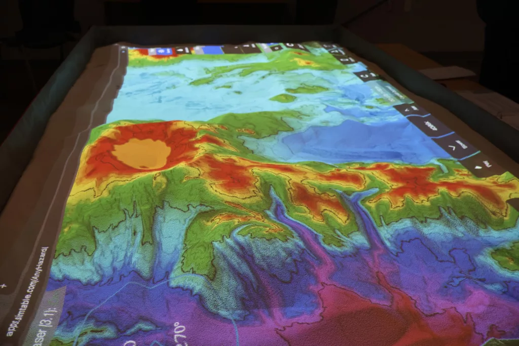
The computer simulator models a flat surface in a 6- by 10-foot box with a transparent topographical map overlay shown from a simtable projector. Any mapped area can be shaped into a 3-D replica of the site to give firefighters a better lay of the land with exacting detail.
“We can recreate Crater Lake and the surrounding mountains,” Hundley said, as he works the simulator to match the topography. “This includes the lake, rivers and streams and timbered acreage to demonstrate where a wildfire may travel given the weather conditions. Then we can study a plan of attack.”
Most importantly, these maps can help establish the quickest evacuation routes for residents given the density of the housing and amount of traffic.
The modeling, Hundley added, also shows the need for homeowners to create a defensible space around their homes, so they have less of a chance of catching fire.
“This is one more step in enabling the KCC program to become a regional firefighting training center,” Hundley said. And, he said, after wildfires, teams can do debriefings on how the fire or other disaster was fought and what they could do better.
“Not only can it aid firefighting efforts, but it can chart natural disasters such as floods, or a toxic chemical spill from a nearby railyard, or downed powerlines. Plumes of smoke are included in the overlay, allowing one to see what areas may be affected,” Hundley said.
“As more homes are built in the in the wildland-urban interface, or homes on the edge of the forests and on hillsides that can be in the direct line of fire, the hope is to have the community better understand the need for defensible space, evacuation routes and overall emergency preparedness.”
For more details on the KCC program, see the link at the website: www.klamathcc.edu