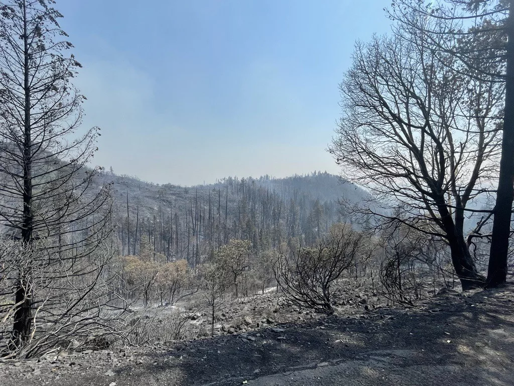
Firefighters working the Salt Creek Fire, located approximately 10 miles east of Eagle Point, were able to largely hold it in its current footprint on Monday, despite another day of triple digit heat and windy conditions. A few spot fires were found on the eastern portion of the incident, and fire began to cross a line on the southern border, however resources caught each of these issues and were able to stop any further spread. Fire activity began to pick up at the change of shift at 6 p.m. and a column of smoke once again stood up, however firefighters will be engaged throughout the night to limit further growth. Tonight, the fire is still estimated to be around 1,500 acres; an overnight infrared (IR) flight has been ordered and will likely be able to give a more accurate size of the fire in the morning.
Despite challenges on the line today, progress was made and the fire is now an estimated 60% lined. Mop up efforts have also begun on the west side of the fire and are 5% complete. Tonight, there are 290 personnel assigned to the incident, including eight 20-person crews, 14 engines, nine bulldozers, seven water tender, and five task force leaders. Resources will focus on holding and securing existing line and building more where possible. Hazardous trees remain a threat to firefighter safety, as does dehydration when working in these extreme conditions.
As of 6:00 p.m. on Monday, the
Oregon Department of Forestry (ODF) Incident Management Team 1 has taken command of the Salt Creek Fire. This transition is relieving local agencies to be able to respond to any new fire starts that are reported. The Type 1 IMT brings extensive staff, allowing it to continue to safely and aggressively stop the spread of this fire, provide information to the community and support the fire personnel of southern Oregon in the response of potential new fire starts.
IMT members were briefed of the fire’s status at 10:00 a.m. and immediately began shadowing the established resources; this transition spans from the firefighters on the ground to the finance, logistics, planning, incident information portions of the incident and more. A dedicated Facebook page for the fire has been established, as well as an Inciweb page.
Beginning tomorrow, updates will be posted daily on these new platforms.
The Salt Creek Fire was first reported Sunday afternoon just after 4 p.m. Both ODF Southwest Oregon District and Lake Creek Fire District initially responded, as well as resources from
Fire District 3, the Jackson County Sheriff’s Office, the Bureau of Land Management, the Rogue River-Siskiyou Interagency Hotshot crews, contract resources from across southern Oregon and numerous large landowners in the area. This effort created a strong and robust initial attack group that worked into the night and early morning hours, and allowed resources to line 40% of the fire within the first 16 hours of the incident.
The
Jackson County Sheriff‘s Office and
Jackson County Emergency Management issued an Evacuation Level 1: BE READY for Zones JAC-316, JAC-317, JAC-319, and JAC-321. These zones are north of Highway 140 approximately 12 miles east of Eagle Point in the Lake Creek area- East of Salt Creek Rd, North of Hwy-140, South and West of Fish Lake Rd, including the Willow Lake area. There are no structures threatened at this time. To find your evacuation zone, visit Genasys Protect:
https://protect.genasys.com/
Salt Creek Road and Wasson Canyon Road remained closed to the public at Highway 140, and Double Day Road is closed off of Butte Falls Highway. Highway 140 and Butte Falls Highway remain open at this time.
Temperatures of 105 degrees and wind contributed to the initial growth of the Salt Creek Fire, along with the dry vegetation in the area and steep slopes. The National Weather Service is now predicting temperatures in the triple digits through next weekend, which will naturally increase fire behavior. Any new fire starts will thrive in these conditions as well. Please be aware of the increased risk of fires starting and spreading, and help reduce the risk by following all current fire regulations.
Starting tomorrow, the fire danger level on the ODF Southwest Oregon District and BLM lands will increase to extreme, and regulations will be in place. Stage 2 campfire restrictions will also be implemented for the Wild portion of the Lower Rogue River starting tomorrow. Please be aware of and follow all current restrictions to help reduce the risk of fires in our communities. Additional information is available here: