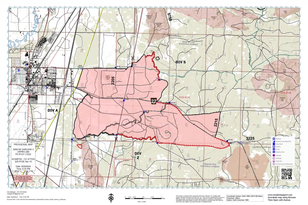
Central Oregon – All containment lines on the Darlene 3 Fire held Saturday night, and the 3,889-acre fire is now 60% contained. Increasing containment and keeping the fire within its current footprint remain the primary focus. Crews will continue to identify and extinguish hot spots within 100 feet of the entire perimeter creating a cool, black line around the fire. Additionally, repair of fire suppression activities will begin to rehabilitate dozer lines and other impacts in the interior portion of the fire.
Since evacuation levels have been reduced and the need for structure protection has diminished, Oregon State Fire Marshal’s Red Team demobilized and returned to their home units on Saturday. Central Oregon’s Type 3 Incident Management Team is now in full command of the incident. At the peak of response there were 435 personnel working the fire. That has been reduced to 304 Sunday as conditions continue to improve. Some resources assigned to the fire are also available to respond to any new starts in the area.
The weather continues to be favorable for fire suppression with cooler than normal temperatures, low winds during the day, and high humidity at night. Some smoke will continue to dissipate but some smoke is expected to remain in the area due to the stable atmosphere, especially in low lying areas.
A Level 2 (Be Set) evacuation level remains in effect for Newberry Estates subdivision and some areas east of Hwy 97. Additionally, all evacuation notices have been lifted for the area west of Hwy 97 and north of Burgess Road. For the most up-to-date official evacuation information please visit Deschutes County evacuation information: www.deschutes.org/emergency. The La Pine Activity Center remains open for RVs to park and has meals for evacuees and N95 masks for those impacted by smoke. N95 and KN95 masks are also available free to the public at both La Pine Rural Fire Department fire stations and the department’s administrative building. Air quality information can be found at aqi.oregon.gov or by downloading the OregonAir app.
With the Fourth of July holiday approaching and temperatures increasing this week fire managers would like to remind everyone to be safe with their celebrations. Possessing, discharging, or using any kind of firework or other pyrotechnic device or using an explosive is always prohibited on National Forest System lands in Central Oregon and currently prohibited on BLM-administered lands in Central Oregon. Fireworks are capable of setting surrounding brush on fire. Consider watching professional fireworks shows and avoid personal fireworks to help protect your neighbors and community from inadvertent fire starts.
For the safety of firefighters and the public, the public is urged to respect the closure area as firefighters continue falling weakened trees throughout the fire area and finish mop up operations. Prairie Campground and the Rosland OHV area and associated trails will remain closed temporarily. McKay Crossing Campground, Ogden Group Campground and 6 Mile Sno Park will reopen at noon today Sunday, June 30. An Area Emergency Closure is also in effect on the Deschutes National Forest, the notice and closure map are available here: https://www.fs.usda.gov/Internet/FSE_DOCUMENTS/fseprd1183408.pdf. Paulina Lake Road and Forest Service Road 22 east of the closure boundary are still open for public use. The Prineville District Bureau of Land Management’s Emergency Public Land Closure also remains in effect. This notice is available online at https://www.blm.gov/programs/public-safety-and-fire/fire-and-aviation/regional-info/oregon-washington/fire-restrictions.
For current wildfire updates, the public can visit centraloregonfire.org or follow fire information on X (Twitter) @CentralORFire or call the Central Oregon Fire Info phone line: 541.316.7711.

